6.1. Groundwater processes#
6.1.1. Introduction#
The flow of groundwater is an important factor in the hydrologic cycle. Precipitation on the surface runs off, evaporates or infiltrates into the ground. After infiltration in the unsaturated zone, the water moves downwards towards the groundwater table under the force of gravity, a process called percolation (NL: percolatie). Apart from infiltration and percolation, the flow of groundwater is mostly in the horizontal direction and is very slow compared to the flow of water in rivers. Groundwater flows from areas of recharge (often originating from rainfall) to discharge in springs, wells, rivers, lakes, and oceans. The base flow of rivers, the flow during extended dry periods, is caused predominantly by inflow from groundwater. A part of the groundwater flows back into the unsaturated zone by capillary rise (NL: capillaire opstijging), which is important for plants and trees to survive extended periods of drought.

Fig. 6.2 Simplified representation of groundwater as a part of the hydrologic cycle. (Own work)#
Knowledge about the presence and flow of groundwater is crucial for our society. Groundwater is the most important resource of freshwater on earth; around 98% of all freshwater is stored as groundwater. Groundwater is mainly used for crop irrigation (65%) and drinking water production (25%), and in many parts of the world it is the only source of fresh water (Hiscock and Bense, 2014).
In most systems, water flows horizontally after infiltration, although there are special cases like polders which have a surface level below the main water level in the surroundings. This leads to so called seepage of groundwater into these areas, which needs to be pumped out mechanically. The groundwater table in these regions is usually high in order to minimize land subsidence and seepage but complicates construction because groundwater control is needed for deep excavations. Using groundwater as a buffer or source of thermal energy or freshwater is a new application for example, especially in the Netherlands this is applied often.
The interest of all these applications has to be taken into account when adjustments are made to the groundwater system.
Groundwater resources are threatened by over-exploitation and contamination. Major problems include a rapid decline of the groundwater table caused by the pumping of groundwater for:
drinking water production;
irrigated agriculture;
salinization of groundwater resources due to heavy pumping in coastal areas;
contamination of groundwater by leakage of toxic chemicals.
Accurate tools and knowledge regarding groundwater flow are required to predict whether the current and proposed uses of groundwater resources are sustainable and safe.
In this chapter, the basic principles of groundwater flow, called geohydrology, are discussed. Although the governing equations are relatively well known, it is hard to make exact predictions because soil characteristics. The in- and outflow of groundwater and flow velocities are hard to measure and highly variable over time and space. Only the head of the groundwater can be determined with high accuracy. Using simplifications allows to obtain exact solutions for many characteristic conditions. These exact solutions provide important insights into the flow of groundwater.
First, a description of the groundwater flow medium is given. The driving force behind groundwater flow, known as the hydraulic head (NL: stijghoogte), is explained and Darcy’s law for groundwater flow is described. The several flow types are briefly recited as well as the different assumptions and simplifications that can be used for each type of flow. Combining Darcy’s law and the continuity equation gives the differential equation for groundwater flow, of which the general solution can be used to solve specific cases using boundary conditions. Other topics briefly covered are: time-dependent flow, seepage, flow towards a well and flow near a saltwater body.
6.1.2. Aquifers#
6.1.2.1. Soil#
The material in the ground can be classified between non-weathered materials called rock and weathered materials called soil. The soil consists of particles and pores. Pores can be filled with water and/or air (see Fig. 6.3). The flow of groundwater occurs in these pores.
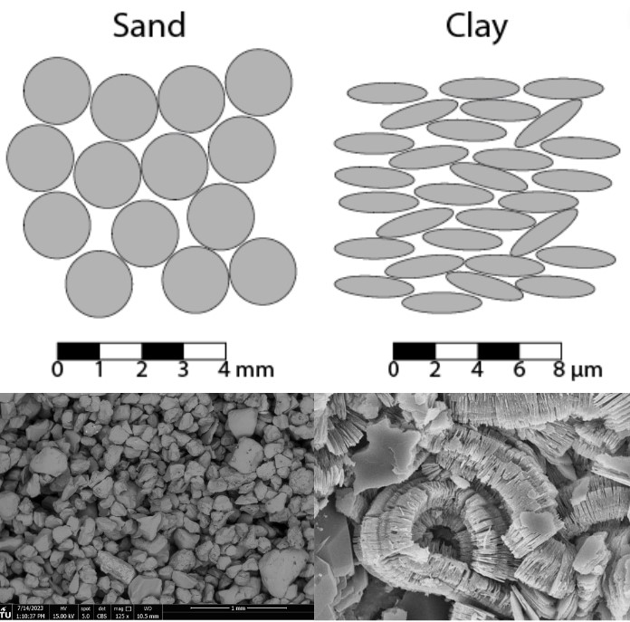
Fig. 6.3 Schematic figure of sand (left) and and clay (right) with pores between the particles (upper panel). Electron microscope picture of clay/sand showing the good connectivty of the pores in sandy (left), and the lack thereof in clayey (right) material (lower panel).#
The ratio between the volume of the pores and the volume of the soil particles is called the porosity of the soil (NL: porositeit van de grond) and is described by Equation (6.1):
where \(n\) is the porosity of the soil [-],
\(V_p\) is the volume of the pores [L\(^3\)],
\(V_t\) is the total ground volume [L\(^3\)],
and
\(V_s\) is the volume of the soil particles [L\(^3\)].
In the top part of the soil, also known as the unsaturated zone, pores in the soil are filled with air or a combination of water and air. Water percolates downwards due to gravity where it reaches the water table or phreatic surface, which is the water level of an open hole in the soil as shown in GW_processes_phreaticsurface. By definition, the pressure of the water is equal to the atmospheric pressure at the phreatic surface. Below the water table, all pores are filled with water.
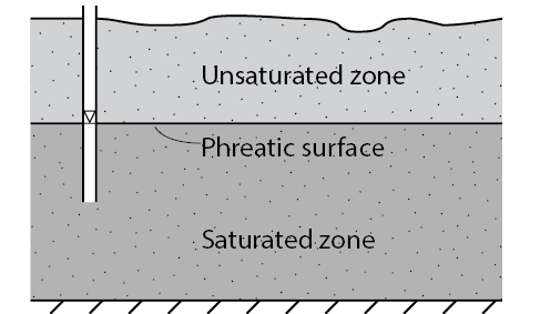
Fig. 6.4 Definition of the phreatic surface. (Own work)#
The hydraulic conductivity (NL: doorlatendheid) of soil is a parameter that describes how easily groundwater can flow through the soil. The hydraulic conductivity depends on properties of the soil (the intrisic permeability \(\kappa\) [m\(^2\)]) and the density (\(\rho\)) and kinematic viscosity (\(\mu\)) of the water which flows through the pores. This relationship is given in Equation (6.2). A high hydraulic conductivity means that groundwater moves easily through the soil. Characteristic numerical values of the hydraulic conductivity for different soil materials are given in Table 6.1.
The subsurface is generally anisotropic, meaning that the hydraulic conductivity of the soil varies with the direction of the flow. This is because the subsurface in the Netherlands has formed through sedimentary processes and therefore consists of many layers of slightly coarser and slightly finer material, causing the average value in the horizontal direction to be greater than the average value in the vertical direction. Compaction of the sediment due to the weight of the layers covering deeper layers causes a general decline in permeability, but has a stronger effect on the vertical permeability than the horizontal. Hence, the deeper you go, the lower the permeability is in general, but also the larger the anisotropy is. In practice, the vertical hydraulic conductivity is often chosen to be five to ten times smaller than the horizontal hydraulic conductivity, although there is no fundamental basis for this choice.
Material |
\(\kappa\) [m\(^2\)] |
k [m/s] |
k [m/day] |
|---|---|---|---|
Clay |
<10\(^{-13}\) |
< 10\(^{-6}\) |
<0.1 |
Sand |
10\(^{-13}\) to 10\(^{-10}\) |
10\(^{-6}\) to 1\(^{-3}\) |
0.1-100 |
Gravel |
> 10\(^{-10}\) |
> 10\(^{-3}\) |
> 100 |
The permeability of the subsurface can be measured using a Darcy device. For this purpose, an undisturbed sample needs to be taken from the subsurface, which is not straightforward. Additionally, it should be noted that the subsurface is always somewhat (and sometimes significantly) heterogeneous, causing the permeability to vary from point to point. Therefore, it is better to measure an average permeability value in the field, for example, using a slug test or a pumping test. Hydraulic conductivity is usually expressed in meters per day or meters per second.
6.1.2.2. Aquifers and confining layers#
Soil consists of layers of different materials like gravel, sand, silt, clay, and peat as a result of geological processes which deposited horizontal layers of sediment material. The properties of these materials vary due to differences in their sizes and shapes. Sand, gravel and silt are granular materials which have pores between the particles where flow can occur. Layers consisting of these materials can therefore transmit significant amounts of water. They are called aquifers (NL: watervoerend pakket) and can be used as a source for drinking water or irrigation. Clay consists of very fine elongated materials deposited in layers. Layers made of clay can transmit little or no water and cannot be used for water supply. They are called confining layers (NL: slechtdoorlatende lagen), aquitards, aquicludes or leaky layers.
An aquifer is called confined (NL: afgesloten) when it is bounded on the top and the bottom by impermeable layers. An unconfined (NL: freatisch) aquifer is not bounded on top by an impermeable layer but by the phreatic surface as shown in Fig. 6.5.
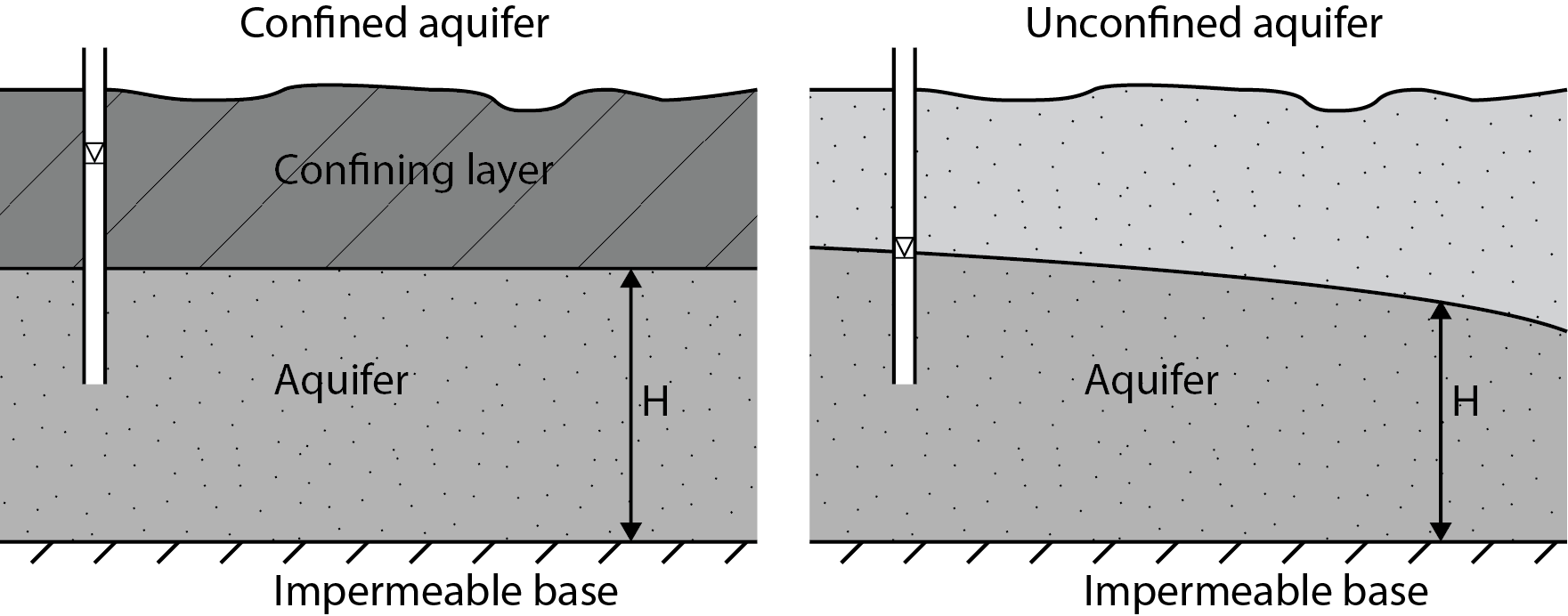
Fig. 6.5 Left: Confined aquifer with the head above the top of the aquifer. Right: Unconfined aquifer with the head equal to the phreatic surface. (Own work)#
6.1.2.3. Water in the unsaturated zone#
The unsaturated zone is the zone between the surface and the phreatic surface (groundwater level). In this zone, both water and air can be present in the pores between the soil particles. Plant root systems develop in this zone in order to extract the water necessary for growth. As a result, the unsaturated zone is essential for plants and agriculture. When the focus of storage and fluxes in the unsaturated zone is related to plants and agriculture, this may also be called agrohydrology.
In hydrology, the unsaturated zone has an important role in the hydrological cycle because its characteristics significantly influence the fluxes which occur, which are shown in Fig. 6.6. Precipitation which is not intercepted (also known as the effective precipitation) either infiltrates into the soil or runs off over the surface. The soil type and the moisture content of the soil determine the infiltration capacity of the unsaturated zone. Subsequently, this capacity determines the amount of water infiltrated relative to the amount of water running off to open water. In the unsaturated zone, water percolates downward to the saturated zone under the force of gravity. The recharge of groundwater depends on the soil type and moisture content of the unsaturated zone because some water is stored in the saturated zone against the force of gravity by capillary forces. The volume of the so called soil water is small compared to the volume of groundwater. It is however very important for plant growth, as plants extract water with their roots and use it for transpiration. Transpiration and soil evaporation lead to an outward flux of water from the unsaturated zone into the atmosphere. The opposite process of percolation can also occur. Water can flow from the saturated zone into the unsaturated zone by capillary rise.
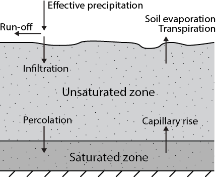
Fig. 6.6 Fluxes of water in and out of the unsaturated zone. (Own work)#
Part of the infiltrated water percolates towards the phreatic surface while part of the water is stored in the unsaturated zone by capillary forces. The soil water is important for plant growth, because plants extract water from the unsaturated zone with their root systems. Knowledge about the presence of water in the unsaturated zone is important for agricultural purposes to optimize crop yield. The amount of water in the soil is expressed by the moisture content of the soil and depends on the availability of water due to precipitation and capillary rise, and the loss of water due to evaporation and percolation which all depend on the characteristics of the soil.
Field capacity and wilting point#
Assume a precipitation event, leading to the full saturation of the top part of the unsaturated zone. In saturated conditions the capillary forces (matric potential) are lower than the force of gravity (elevation potential), so the water percolates downwards to the phreatic surface. Capillary forces increase because the moisture content decreases by percolation. At a certain soil moisture content the matric potential equals the elevation potential, and water stops percolating towards the phreatic surface. This occurs within several days after the precipitation event. The moisture content of the soil where no water percolates downwards is called the field capacity. The field capacity depends on the soil characteristics.
The soil can dry out due to evaporation from the soil and extraction of water by plant roots. In that case, the moisture content becomes smaller than the field capacity. A decrease in the soil moisture content leads to an increase of the capillary forces (matric potential). At a certain value of the soil moisture content the capillary forces are too high for plants to extract any water. At this point the plants start to wilt; also known as the wilting point of the soil. Just like the field capacity, the soil moisture content where the wilting point is reached depends on the soil characteristics.
When the phreatic surface is high, capillary rise of water occurs which leads to a higher soil moisture content. The wilting point is therefore reached after longer periods in regions with a high groundwater table.
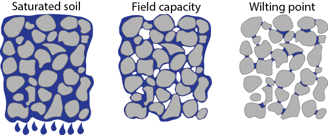
Fig. 6.7 Moisture in in a saturated soil, one at field capacity and one at wilting point. (Own work)#
Soil moisture characteristic curve#
For every soil type, the soil moisture characteristic curve can be obtained. This is the relationship between the soil moisture content \(\theta\) in a soil and the observed matric potential \(\psi\) in the soil, where stationary conditions are assumed. The matric potential is a pressure and is expressed in Pascals (Pa) instead of meter water column. Another value often used in literature is the pF-value, which is the logarithm of the absolute value of the matric pressure expressed in centimeters. A suction pressure of \(10^3\) Pa is equal the pressure of a column of water with a height of 10\(^5\) cm which can be written as a pF-value of 5. The pF-value is used because of the large variation in the absolute value of the matric potential. The soil moisture characteristic curve for different soil types is shown in Fig. 6.8 based on Bolt et al. (1972).
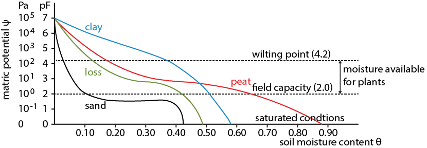
Fig. 6.8 Soil moisture characteristic curve for four soil types.#
As shown in Fig. 6.8, the field capacity of all soils is around \(pF = 2\) or \(\psi = 10^2\) Pa. In reality this often varies between \(pF= 1.8\) and \(pF=2.2\). The wilting point is the same for different soils and is usually taken as \(pF = 4.2\) or \(\psi = 10^{4.2}\) Pa. The water available for plant growth in a certain soil is the difference between the soil moisture content at field capacity and the moisture content at wilting point.
Soil types#
Different soil types have different characteristics as shown in Fig. 6.8. Sandy soils store small quantities of water at field capacity. The soil moisture available for plants is very low in these soils, with a difference between the soil moisture content at field capacity and at wilting point of 0.07 (\(\Delta \theta \approx 0.07\)). Sandy soils are therefore vulnerable for droughts.
More water is stored in clay soils with a moisture content at field capacity around \(\theta \approx 0.55\). The water available for plants is larger than for sandy soils, around \(\Delta \theta \approx 0.16\). A large part of the water in clay soils cannot be extracted by plants due to the high matric potential.
Peat soils have the largest soil moisture content available for plants (\(\Delta \theta \approx 0.46\)). On top of that, the soil moisture content at field capacity is large (\(\theta \approx 0.65\)).
